Twitter YouTube
NM RGIS
 
Skip to content
  • About
  • Get Data
  • FAQ
  • GIS in Practice
  • Resources
  • Donate

Tag: Climate

NM WRRI Acquires PRISM Climate Data

  By sandeep May 5, 2015 May 6, 2015 GIS In Practice
New Mexico precipitation and temperature data from PRISM

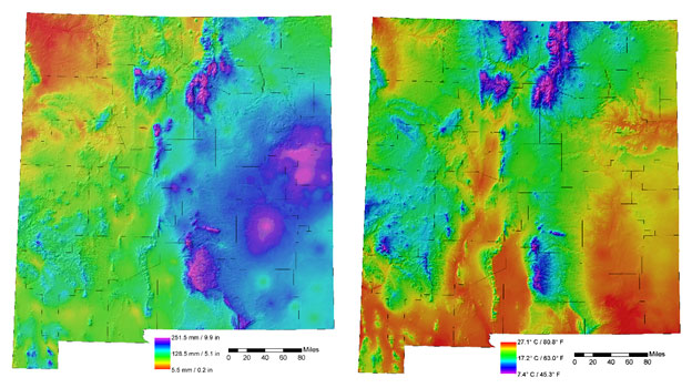
Guest Post by Steve Walker, GIS Coordinator with the New Mexico Water Resources Research Institute | From the April 2015 issue of the NM WRRI New Mexico Water eNews Newsletter Before the advent of reliable geographic information systems (GIS), official, 30-year average, hand-drawn climate maps for the U.S. were produced… Continue reading

Tagged   Climate, NM WRRI, PRISM
  • RGIS News

    • RGIS Funding
    • New Mexico Lidar Data Status Map
    • RGIS – New Data Portal
    • DEM Analysis – The many uses and derivatives of a Digital Elevation Model
    • Clandestine Meth Labs in New Mexico
    • Using Leaflet JS to map mines in and around New Mexico
    • Implementing Web AppBuilder for ArcGIS at the City of Rio Rancho
    • Updating Archeological Site Field Data Collection Methods to Twenty First Century
    • Up in Flames: Creating Defensible Spaces to Reduce Wildfire Damage
    • NM WRRI Acquires PRISM Climate Data
  • Tag Cloud

    3D Analyst 3D Elevation Program 3DEP Animas River Spill ArcGIS Blackdom Cadastral City of RioRancho data collection DEA DEM Drought Elevation ESRI Flood GAC geojson Ghost Town GIS Tips Groundwater Harvey House Historic Imagery JavaScript LeafletJS Lidar Meth Labs Mines Model Builder NAIP New Mexico PLSS QGIS Reservoir RGIS SNOTEL Snow cover Spatial Analyst Story Map Surface Analyst Township USGS Water Web AppBuilder Wildfire
  • Archives

  • Earth Data Analysis Center/RGIS Support Fund

  • Tweets by @nmrgis
All content Copyright © 2015 by the Earth Data Analysis Center, University of New Mexico
Phone: (505) 277-3622, Email: clearinghouse@edac.unm.edu
Powered by Parabola & WordPress.
Twitter YouTube