Twitter YouTube
NM RGIS
 
Skip to content
  • About
  • Get Data
  • FAQ
  • GIS in Practice
  • Resources
  • Donate

Category: GIS In Practice

New Mexico’s Ghost Towns Landscape

  By sandeep January 9, 2015 January 30, 2015 GIS In Practice
nm_ghosttowns

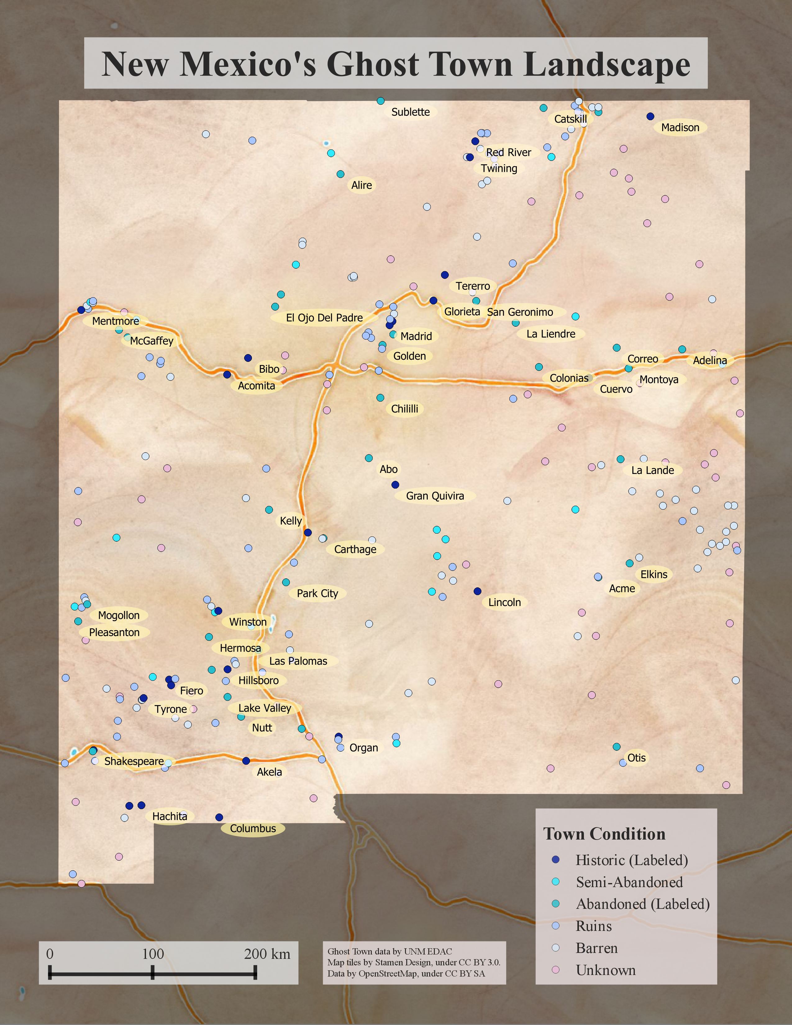
New Mexico’s history of mining and exploration makes it home to hundreds of abandoned settlements. Intrepid research into the history of these settlements yielded a compilation of our state’s documented ghost towns. Here is a link to the interative map. The data used to create this map, which includes names,… Continue reading

Tagged   Ghost Town, Historic, New Mexico, RGIS

How is Wildfire Affecting New Mexico?

  By sandeep January 8, 2015 January 30, 2015 GIS In Practice

The past three years have seen over 648,000 acres of land burned in New Mexico due to wildfire. Many of the RGIS data sets can be used to assess the effect of wildfire on the landscape of New Mexico. RGIS has New Mexico Fire Burn Severity data from 1985-2010 in… Continue reading

Tagged   Drought, New Mexico, RGIS, Wildfire
123
  • RGIS News

    • RGIS Funding
    • New Mexico Lidar Data Status Map
    • RGIS – New Data Portal
    • DEM Analysis – The many uses and derivatives of a Digital Elevation Model
    • Clandestine Meth Labs in New Mexico
    • Using Leaflet JS to map mines in and around New Mexico
    • Implementing Web AppBuilder for ArcGIS at the City of Rio Rancho
    • Updating Archeological Site Field Data Collection Methods to Twenty First Century
    • Up in Flames: Creating Defensible Spaces to Reduce Wildfire Damage
    • NM WRRI Acquires PRISM Climate Data
  • Tag Cloud

    3D Analyst 3D Elevation Program 3DEP Animas River Spill ArcGIS Blackdom Cadastral City of RioRancho data collection DEA DEM Drought Elevation ESRI Flood GAC geojson Ghost Town GIS Tips Groundwater Harvey House Historic Imagery JavaScript LeafletJS Lidar Meth Labs Mines Model Builder NAIP New Mexico PLSS QGIS Reservoir RGIS SNOTEL Snow cover Spatial Analyst Story Map Surface Analyst Township USGS Water Web AppBuilder Wildfire
  • Archives

  • Earth Data Analysis Center/RGIS Support Fund

  • Tweets by @nmrgis
All content Copyright © 2015 by the Earth Data Analysis Center, University of New Mexico
Phone: (505) 277-3622, Email: clearinghouse@edac.unm.edu
Powered by Parabola & WordPress.
Twitter YouTube